Rules and Regulations
General
Pac Tom is a single-player game whose purpose is to run the length of every street in Pittsburgh, Pennsylvania. Pac Tom takes several years to complete.
I do this in a series of trips. Each trip must start or end (usually both) at "home", and can go anywhere on foot (including off-road). I keep track of where I go using a wrist-worn GPS device. The first time I'm on a road segment I must run it; after that it's acceptable (but wimpy) to walk. I can stop to rest any time, if I am a wimp. I mark off completed roads on a map after the trip, marking non-roads so that it's clear that there's nothing to do there, and occasionally correcting the route if there's some problem with the GPS trail.
What counts as a road?
There's a lot to say about what counts as a road. My basic philosophy is: If you can drive a car on it and I can legally and safely run on it, then it counts. There are lots of corner cases to consider, particularly in Pittsburgh.
Missing roads.
I use Google Earth as the official word on what roads I must do. The maps are great, but I usually encounter multiple errors per trip. The most common error is a road that's on the map but not in reality: Sometimes it's clear that it was once there and is now overgrown, sometimes it's actually a driveway, sometimes there's no hint of it at all. (I think that map providers actually deliberately introduce fake dead-end roads as watermarking so they can detect if people copy their data.) Missing roads aren't there so I don't require myself to run on them. If it's merely run down or I can't quite tell, sometimes I go for it anyway, since it can lead to adventure.Roads not on the map.
Less commonly, I spot roads while running that aren't on the map. When I see them I do them, because for one thing I know that the map might later be updated to add them (see "winning the game" below). However, I have to consider these optional because I have no way to keep track of the roads unless they're on the map.No trespassing.
Sometimes "roads" turn out to be private drives, or have "no trespassing" signs, or are gated with security guards, razor wire and land mines. I consider these optional unless there's clearly nobody around to stop me. I think that a lot of the time, these are actually public roads that were just claimed by someone as no trespassing private by making a hand-made sign.Highways.
Highways are often excluded, because it's usually visibly illegal to run on them, and often pretty unsafe. In Pittsburgh, interstates 376, 579, and 279 are basically undoable, except in special circumstances like road races or closures for construction. (In do take advantage of situations like that, but consider them optional.) Most state highways are doable (many have sidewalks within the city limits) except for occasional parts with no safe passage. In terms of length they don't account for much of the total roadage in Pittsburgh, so I don't feel bad about leaving them out. I mark unsafe areas with skulls on the map.Bridges and tunnels.
Pittsburgh has lots of bridges spanning its rivers and valleys, most of which have sidewalks or bike lanes. I include those—the ones crossing the rivers are not technically in any neighborhoods (see "winning the game" below) but they're some of the most scenic spots in the city. Most tunnels are not designed for anything but motor vehicles, and GPS does not work in them, so those are excluded. (The Armstrong Tunnel surprisingly does have pedestrian passage, which I have enjoyed.)Stairs.
Pittsburgh has the odd feature that many of its official "roads" are actually staircases. I exclude these on the grounds that they cannot accommodate cars. Running on stairs really sucks, anyway. They're also among the most likely "roads" to be missing, or impassable because they're broken or overgrown. That said, stairs are sometimes useful shortcuts (especially in the South Side Slopes) and I've actually done a good fraction of them as part of a friend of mine's kindred project to hike all Pittsburgh's stairs in group outings.What does the length of every road mean?
If roads had start and finish lines and no intersections this would be easy. But there are many complications. For dead ends with a clear terminus (say, Jersey barrier) I aim to get within a car's length of that thing. If there's a cul de sac with a center, I run around that dot. If the road just kind of peters out, then I have to make a guess. Sometimes there will be a long dead end that gradually becomes someone's driveway out in the middle of the woods, and at the end they're all there having a cookout like in the driveway and a basketball game also spanning the driveway and obviously this road goes nowhere except the cookout and they've never seen a runner here before ever, and they're all quizzically looking at me, and in those cases I'm like Hey what's up guys? and I turn around without getting to the very end.
Running sidewalks, gutters, bike lanes, grassy embankments, medians, sidewalks that are actually stairs, and all that stuff count as running the attached road. I usually run on the sidewalk if it's available. For divided highways, I only require myself to go on one lane, but there aren't many of these in Pittsburgh and most of them I've done both sides anyway, for variety.
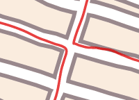
The width of intersections themselves are optional; I only care about the segments of road in between. For example, I might enter a four-way intersection twice, like this:
What counts as home?
My philosophy here is don't go out of my way to pick a convenient start/end spot. Home is usually my house, my office, or a friend's house if I'm staying there for some other reason. These have all been located in roughly the same part of town (Shadyside / Squirrel Hill). Because organized road races are a rare opportunity to run some road segments (like highways) that are otherwise too dangerous to do, I also allow road races to count. I don't have any control over the start or end points of these, so that's consistent with the philosophy.
Probably 90% of my runs both start and end at home. The reason for the start or end option is that I sometimes find myself injured or unexpectedly wiped out and need to walk home (and it would be a particular indignity to not count the running done on such painful trips). I used to occasionally do stuff like catch a ride to the Waterfront shopping center and run back from there, or go with my brother to his hockey game and start the run from the park, but I don't do that much any more.
What counts as running?
I am pretty lax about what counts as running, at least compared to what I'd do racing or training. Basically my philosophy is don't wimp out. Most of the time I'm doing a leisurely 8m30s–9m30s pace, which for me allows for the greatest distance and injury avoidance. If it's a big uphill and I'm wiped out, it could be much slower, quite sorry-looking I'm sure. If I've got pep or I'm feeling masochistic, could be faster. I seem to have some internal notion about what running is (versus walking) which is independent of speed and hard to articulate, but you probably know what I mean. You could take the definition used to prevent race walkers from being race runners: It's running if both of my feet are off the ground at some point during the stride.
Winning the game
After playing Pac Tom for some time I realized the road system actually changes significantly at the year-by-year scale, and that Google frequently makes updates to their map data. To reduce despair (e.g. thinking that I was done with all of the roads in some distant section of town but seeing a new tiny dead-end road that might not even be real pop up there a year later) I need some account of time in the rules. The rule is: If at any time I've run every road within a neighborhood (these are officially defined by the city) according to the map, then I can mark that neighborhood off for good and not worry about new roads or map changes there. Until a neighborhood is finished, I have to live dynamically. Once all neighborhoods are done, I win.
Pac Tom Level I is the parts of the city between the Allegheny and Monongahela rivers, about 23.5 square miles. I completed this region on 18 November 2008. Pac Tom Level II is the remainder of the city, another 32.5 square miles, and still in progress.
